STAR RIVER

Tanker

FacebookLinkedInTwitterRedditVKPrint

Information related to the Tanker vessel STAR RIVER (MMSI 538007747, IMO 9815458) from Marshall Islands with latest positions and portcalls.

MMSI538007747
IMO9815458
NameSTAR RIVER
Country Marshall Islands
MMSI TypeVessel
TypeTanker
Call SignV7DR6
ClassA
Id5c74f8de6401fa61ea554432
Course315.1
Speed (kn)11.5
Heading (°)317
PAC
ROT8.749496513347962
StatusUnder way using engine
Leaflet | © OpenStreetMap contributors

First Seen6 years ago
Last Updatea month ago
Positions629
Latitude-34.37676833333333
Longitude17.761195
Length (m)180
Width (m)30
ETAJan 22, 2020 12:00 AM

Distance travelled (nm)

Since first seen347116.51
Since last port call839.49
Since last position0

Estimated Load

68%

Speed (kn) / Draught (m)

2728293031 1 2 3 4 5 6 7 8 9101112131415161718192021222324January 2025February 2025

Draught (m)

Current9
Min6
Max10.4
Average8.1

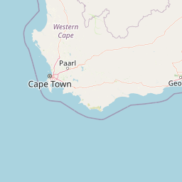
The Tanker vessel STAR RIVER (mmsi 538007747) from country Marshall Islands is currently located at -34.376768 S 17.761195 E and the last position is sent a month ago. At the moment the vessel is Under way using engine heading 317 degree at speed 11.5 knots, and its current draught is 9 meters. The vessel is long 180 m and large 30 m, and it's estimated to be loaded at 68%.

Timeline

The following timeline will display the list of porcalls and other events regarding the ship including tracks.